Okay, no photos, no maps, just a short post to let all know I have arrived at this major Argentine city after a long day on the road, which was made longer and more complex thanks to the fact that that last partiers to leave Cafayate after their annual Serenata de Cafayate drained the gas pumps dry at the only station in town...actually, the person in line in front of me got gas, but maybe it was diesel. Regardless, when the attendant tried to pump mine (with nafta, as they call the unleaded stuff here) the reservoir was all tapped out. They then told me that I would have to wait until mid-day tomorrow (yikes!) for their tanker truck to arrive...
Well, all that was just too dismal to contemplate, so I considered my options. I asked the attendant how far was the next station south of there, and she told me I could get gas at Santa María, a gritty little city about 70 km south. Well, I knew I could make 70 kilometers, so off I went. Trouble was, it was off my planned route, and once I got there I had a heck of a time locating the town´s mgas station. But at least the attendant there was able to accurately describe for me how to get back onto the highway I´d made the long detour from to buy the precious fuel.
Then for a time the drive became spectacular, going up into some impressive mountain terrain with vast stands of huge Cardón Cacti and then a surprise once I got up to the summit overlooking the valley below with its attractive town of Tafi del Valle sitting like a pearl at the bottom - but alas, the valley was socked in with a thick cloudbank, which would prove to be the leading edge of a rather nasty storm front, which meant that I had to maneuver the Toyota through a massive rainstorm for much of the afternoon. It got quite treacherous when I made the connection with Ruta Nacional 38, which rolls through north-central Argentina in a large arc and which I will be following practically all the way to Villa Dolores, my planned destination for the day after tomorrow.
But the rains subsided as I approached Catamarca (Officially named San Fernando del Valle de Catamarca), and when the clouds broke, the heat settled in. I´ve done my share of sweating in this intense subtropical heat, which is of course augmented by the humidity from all the rain...Actually, the rains started last night when I was settling in to my last night in Cafayate. It was an impressive sustained downpour, complete with all the thunder and lightning, and I do believe there has been some flooding, especially in some of the places I drove through this afternoon when the rains were filling many of the rivers.
Anyway, I made it here, safe and sound, and will be planning to get a decent start in the morning. I want to at least get to the city of La Rioja, but will probably get past there, maybe as far as Chamical, east of the Sierra de Los Llanos, or even to Castro Barros, out on the Salinas Grandes. I am not so sure that either one of those potential destinations will afford me the opportunity to report in to the blog as they are not much on the map, but they will get me well within striking distance of Villa Dolores on March 2nd.
So whenever I can, I´ll be back here, posting new stuff, and hopefully some new pics. So stay in touch, amigos.
Wednesday, February 28, 2007
Monday, February 26, 2007
NORTHWEST ARGENTINA ADVENTURES
 And now, as promised, here follows a rather lengthy recounting of the adventures of the last few days, primarily during the time while I was out of contact with the virtual world and deeply connected with the real one, at least as it exists here in this most spectacular and vast corner of it. In yesterday´s post I had already posted a self-portrait taken while I was out on my hike on the 23rd of February, taking in the stunning landscapes there in the remote realms of Argentina´s Jujuy Province. The above picture will give you a sense of the terrain and its raw beauty. That was the spot where I stopped to enjoy the snacks I had brought along and re-hydrate myself with fluids.
It was, as you can imagine, a sublime day spent communing with the Pachamama (Earth Mother) spirit, which is still much revered by the Quechua peoples there in the Susques region, the anciuent, indigenous predecessor to the Catholic Church which also claims the loyalties of the locals.
 The next day I left my convenient accomodations at Pastos Chicos, which is really the only place to stay in Susques. I was determined to make it all the way to the marvelous little city of Cafayate, which is in neighboring Salta Province.
 Knowing that I had my options as to which route I should take, but also that the paved route that goes through the cities of San Salvador de Jujuy as well as the metropolis of Salta itself, I opted to go once more on the shorter (and presumed faster) unpaved route that would lead me back up onto the heights of the mountains east of San Antonio de Los Cobres, and the treacherous high mountain pass known as Abra del Acay, which my antiquated Argentine guidebook (published by Argentina´s YPF) calls the highest motor pass in the world, some 4970 meters above sea level (which translates to about 16,300 feet altitude!) The above image shows one view from that summit.
Now as my luck would have it, I became an unintentional collaborator in a rather tedious two-vehicle recovery effort which involved:
1.) A Hertz rental car that some American tourists had rented in Salta and had foolishly tried to take over the high Abra del Acay summit - a 2wd, low-clearance car, which is literally crazy considering that all guidebooks warn that only high-profile 4x4 vehicles should attempt the pass.
2.) A tow truck belonging to Auxilio, a mobile auto repair outfit that operates out of Salta, who advertize that they will service anything "within 500 miles of Salta," which had broken down on its attempt to reach the abandoned Hertz rental car that the gringoes had left half submerged in the raging mountain river that the route crosses a half-dozen times.
Anyway, to make this very long intro a bit shorter I will say that once Hertz learned that Auxilio´s recovery tow truck had broken down, they sent out their own recovery team to try to extract their rental vehicle from the river, while Auxilio sent a second tow truck, with two drivers, to try to salvage both their own broken down truck and also the lost Hertz vehicle. I came into the picture as I happened to be driving into the route from the north, and soon found myself coming along behind the Auxilio recovery tow truck. In front of them was another vehicle, a pickup truck driven by a businessman from Cafayate and acompanied by his girlfriend. They were out for a drive in the country, ostensibly to avoid the crowds in Cafayate that weekend for the town´s annual "Serenata de Cafayate," a huge folk music festival. They suddenly broke down, and the Auxilio guys were thus forced to lend assistance to try to fix what turned out to be only an empty gas tank (the Cafayate businessman luckily had somme spare gas in an auxiliary can). 

Anyway, he stopped at the summit while the Auxilio team and I continued onward down the south slope to the point at which their broken-down rig was. I stopped with them, knowing that it would be foolish to continue on this narrow road knowing that the abandoned Hertz vehicle would be blocking my passage. So I offered to lend a hand to the two Auxilio mechanics. They sent me out on foot to do reconnaisance of the route below where they were laboring on the clutch of the broken-down tow truck. The route ahead was ugly, and I reported back to them that I felt that either of their vehicles might not make it past a very narrow and washed-out stretch some 500 meters down from us. Anyway, that grim fact was dismissed when the Hertz recovery team came along, slugging their way uphill with their abandoned rental car (obviously undrivable) in tow. Once they reached our place in the road, the job became one of fixing and extricating the damaged tow truck as well as the inoperable rental car.

We then formed a rather impromptu caravan, as the chief of the Hertz crew, a fellow named Pedro Foa, strongly advised me to abandon my plans to try to go on down through the most ruggewd part of the road, which is the part where the road crosses the rampaging mountain river some half-dozen times. Okay, so I was going back these guys, and would loise a day in my quest to get to Cafayate.

We then formed a rather impromptu caravan, as the chief of the Hertz crew, a fellow named Pedro Foa, strongly advised me to abandon my plans to try to go on down through the most ruggewd part of the road, which is the part where the road crosses the rampaging mountain river some half-dozen times. Okay, so I was going back these guys, and would loise a day in my quest to get to Cafayate.
Once the Auxilio guys had fixed the clutch on their tow rig, the next problem would be how to turn the massive vehicle around on the narrow canyon road. It was not hard for me to turn my pickup around, and they Auxilio guys were also able to turn their recovery tow truck around, but this original tow truck was just too long to pull it off. They ended up using the recovery tow truck to tow the bigger truck sideways while we all pushed on it, to swing it around without it going over the edge! Once that was acomplished, we set out in tandem to go back over the summit and go back to San Antonio de Los Cobres.

We determined that the two damaged vehicles should be front and back, with the good tow truck and me in the middle. In that order we inched our way back to the summit, where we stopped to tke part in a rather crude but rewarding "lunch break."

We determined that the two damaged vehicles should be front and back, with the good tow truck and me in the middle. In that order we inched our way back to the summit, where we stopped to tke part in a rather crude but rewarding "lunch break."
This picture shows the two Auxilio drivers saluting me while Pedro Foa of Hertz looked on.
And the next picture shows our caravan as it was parked at the summit of Abra del Acay. Considering the treacherous nature of the road still before us, it would take us another two hours to get our vehicles down the mountain and make

the 45 km drive back to San Antonio de Los Cobres.
So the next day I set out on my second day´s attempt to get to Cafayate. In retrospect, of course, I wished I would have thought to have taken Ruta 51 from San Antonio de Los Cobres in the direction of Salta instead of trying that awful mountain road, but naturally I didn´t know. But what I encountered was another spectacular bit of impressive Northwestern Argentine 
scenery, which made the lost day seem even more bittersweet. This picture here shows just a small glimpse of some of the rugged beauty on this route, with a forest of Cardón Cacti populating an arroyo in the very beautiful Quebrada de Toro, which the route follows for a long distance.

scenery, which made the lost day seem even more bittersweet. This picture here shows just a small glimpse of some of the rugged beauty on this route, with a forest of Cardón Cacti populating an arroyo in the very beautiful Quebrada de Toro, which the route follows for a long distance.

Farther on the vegetation becomes more lush, as one can see in this shot which looks up the quebrada and back at the small-gauge railroad bridge that crosses the Río Toro. It was a very beautiful drive, and I was so glad to finally make it into Cafayate yesterday at around 4 p.m. Buit of course, the place was mobed with people, as it was the last night of the Serenata de Cafayate set to begin. Although I would have loved to have gone to take in some of the music, I was more preocupied with some more pressing and certainly more plebian necessities: namely finding lodging and then getting some food and water into my system. Then, once that was taken care of, I could finally go out and enjoy some of the finest wine produced on the planet: Organic Malbec wine, locally produced at one of the several great wineries located here in Cafayate.
So that´s my story, and you should now consider yourselves all brought up to date. Today I am getting my laundry done, and then I will be here for one full day to relax, tomorrow. I will then set out on a rather urgent push to get to the town of Villa Dolores, far south of here, and west of the major city of Córdoba. They used to call such a long haul "ballin´the jack," so I guess that is what I will be planning to do on the last day of the month. I am scheduled to arrive ion Villa Dolores on March 2nd, the guest of the family of my friend Matias Martino whom I met on Tierra Del Fuego back during my first trip down to South America in 2002-2003.
Sunday, February 25, 2007
CAFAYATE, ARGENTINA, or BACK IN "CIVILIZATION" AFTER EMERGING FROM REMOTE JUJUY PROVINCE
 Okay, so here I am, safe and sound after some time in that most remote northwest corner of Argentina - a veritable modern day "terra incognita," if you will. Oh, I´ve had some adventures, so I´ve got some stories to tell, but that will have to wait for tomorrow´s more substantial post, complete with extensive dialogue and significant photo coverage. I invite all to come on board in 24 hours to check it all out.
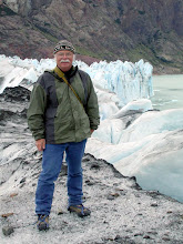
For now though, just be aware that I am alive and well, but of course my original travel plans have had to be changed following the events that took place up in the more remote parts of Jujuy Province. Incidentally, the above "self-portrait" was taken by yours truly while on an extended hike outside of small pueblo of Susques, and the shot below was taken yesterday, on the road to San Antonio de Los Cobres, en route to the mythical high mountain pass, Abra del Acay.
 Today I have finally reached Cafayate, a full two dasys behind schedule, but that´s not an uncommon thing on trips like this. I will be in Cafayate for three nights, and then comes a big push to get to the city of Villa Dolores, west of Córdoba on February 2nd, before going on to Mendoza and back to Chile. But that is still all so much in the future, you know anything can happen before then!
 Anyway, so please come back tomorrow for a fully detailed account. It ought to make for some interesting reading...
Saludos, amigos.
Wednesday, February 21, 2007
SAN PEDRO DE ATACAMA TODAY, THEN ON TO ARGENTINA TOMORROW
 Today I have reached the oasis town of San Pedro de Atacama, my last stop before crossing over the roof of the continent at Paso de Jama and on into Northwest Argentina, with a projected one night stay tomorrow night in the Quechua Indian pueblo of Susques before continuing on to Salta and Cafayate. The computer at this internet cafe has a painstakingly feeble internet connection, so again I am posting maps instead of photos, ostensibly to preserve my camera batteries from wholesale drainage.
 The map above is of the town of San Pedro, which is not only an oasis in terms of agriculture here in the higher reaches of the Atacama Desert, but is also something of a neo-hippie bohemian outpost in a very remote but beautiful part of Chile. To the northeast, the Bolivian Cordillera reaches upwards toward the skies, dominated by the immense snow-covered Volcán Licancabur. Tomorrow I will drive past Licancabur and up onto the high altiplano and on to my planned routes south through Argentina.
 Te above map shows the tenuous route I will be following across Northwest Argentina from Paso Jama on the far left, and finally into the strikingly scenic Quebrada de Humahuaca and Argentine RN 9 which will lead me through The cities of San Salvador de Jujuy and Salta before my arrival in that wonderful little gem of a town known as Cafayate. AS a matter of fact, I do not believe I will be able to post anything here until I have reached Cafayate, which will not be for a couple of days. For those of you who recall my adventures in this part of Argentina back in February of 2006, you will remember that this stretch of highway east of Susques was where I had my fateful collision with a llama, which was the saddest and most effecting moment in that whole 3½ months of touring.
 This last schematic illustrates the elevations (in meters) of my climb up onto the altiplano and then the eventual descent into San Salvador de Jujuy. The highest points are real rarified air excursions - 4600 meters equals about 15,000 feet elevation! Breathe deep and move with measured efforts...
I´ll catch you all on the other side.
Chao, amigos.
Sunday, February 18, 2007
PREMIERE TALTAL LANDMARK DESTROYED BY FIRE
 Yesterday I arrived here in the sunny and laid-back town of Taltal (pop. 15,000) which has, by the very pleasant nature of its ambience, become one of my favorite places in all of Chile. After getting settled in to my usual digs at the frumpy little Hotel San José, I was determined to get the post put up here on the blog about Parque Nacional Pan de Azucar, but my feelings in that regard were far overshadowed by the shocking discovery I´d made upon my arrival that Taltal´s beautiful Catholic church (built in 1890), the town´s premiere landmark and staging center for the annual religious festival, had burned to the ground back on January 6th, 2007.
The tragedy could have been worse, but for the fact that the town´s fire station was right next door to the church. Still, the structure was completely destroyed, and the rectory and church offices alongside the church were similarly gutted, which prompted the city fathers to conduct last weekend´s festival services in the plaza across the street from the ruins of the burned buildings.
I would post a picture but it would show only a vacant lot of charred flooring joists as the only reminder of the former glory now gone. Instead, I´ve posted my Turistel map of Taltal, on which you can see the plaza slightly left of center, with the "Iglesia" facing it across Avenida Arturo Prat, the town´s main street.
Anyway, since the church was sort of Taltal´s "flagship" landmark featured on all of their tourist literature, they are already planning to rebuild it. So perhaps on some future visit to this fine little outpost of tranquility (22 km off of the Panamerican Highway on the coast) I will be able to see the landmark restored.
Incidentally, I will be here in Taltal until Tuesday morning, when I leave for Calama. MY agent Andrés is supposed to be sending my permit to cross to Argentina in his rented 4x4 pickup truck to the Chile Express offices in Calama on Tuesday. Without the permit, I cannot go into Argentina. So we will see if he comes through. I suspect that he will.
Saturday, February 17, 2007
PARQUE NACIONAL PAN DE AZUCAR
 Here´s a veritable little gem of a park, Chile´s Parque Nacional Pan de Azucar, and now that I´ve visited it, I am scratching my head wondering why in the world I never took the time to visit it during my first two visits to Chile. Well, my Agent Andrés insisted that I needed to go there, by saying that he is "always looking for new places for you to explore."
Pan de Azucar was created in 1985 with the intent to preserve and protect the natural ambience, as well as the unique flora and fauna of this specific coastal region in the Atacama Desert. One feature is the striking small island, Isla Pan de Azucar, which lies right off the coast from El Soldado campground and is the home and nesting ground for a population of Humboldt penguins. Locals offer boat rides to the island for tourists to see the penguins as well as the other maritime animals such as a local herd of sea lions. The above sunset photo shows the proximity of the island to the mainland.

Here is the view from the fabled Mirador, which gives the visitor a better appreciation of the coastline in the park as well as offering a wonderful opportunity to see and appreciate some of the native plant species that have become adapted to survive on the mists from the ocean fog, as it hardly ever rains here.
The scenery here in the park is as varied as it is spectacular. Golden sand hills give way to stark chocolate bands of sediment on jagged escarpments. In all, I would say Andrés was right when he insisted I visit this park, and I only regret that I did not have more time to explore it further.. But I guess that only means I will need to do so on a future journey.


Friday, February 16, 2007
ACTIVISTS MARCH IN VALLENAR
 Citizens of Vallenar and other communities in Chile´s Valle del Huasco came together yesterday and held a protest march which began in the city plaza and continued through the center of the downtown district of Vallenar. The purpose of the march was to protest against the exploitative gold mining project being pushed through by the Barrick Gold Mining company in allinace with mining interests in bothj Chile and Argentina.
Many people believe that the project, known as Pascua-Lama, will be a serious environmental disaster , since it will cause major disruptions to the high regions up in the Andes that will require the destruction of three glaciers which are the source for the waters which the communities down stream in both Chile and Argentina depend on for personal and commercial uses. Besides the destruction of these essential glaciers, citizens are concerned that the chemicals that will be used in the gold extraction process will not be adequately contained, nor will the sterile discharges from the process be kept from polluting the valleys below. One of the protester´s signs pointed out that the choice was between "Agua Limpia u Oro Sucio" (Clean Water or Dirty Gold).
 , since it will cause major disruptions to the high regions up in the Andes that will require the destruction of three glaciers which are the source for the waters which the communities down stream in both Chile and Argentina depend on for personal and commercial uses. Besides the destruction of these essential glaciers, citizens are concerned that the chemicals that will be used in the gold extraction process will not be adequately contained, nor will the sterile discharges from the process be kept from polluting the valleys below. One of the protester´s signs pointed out that the choice was between "Agua Limpia u Oro Sucio" (Clean Water or Dirty Gold).
It was interesting to see so many young Chileans actively protesting against Barrick and their plans to extract this gold from high up in the Andes. I do hope that there is some way to bring the governments to their senses to stop this exploitation, which will doubtless cause great problems for the people, not only those who live down from the mining project in the Valle del Huasco, but in all of Chile and Argentina as well. I for one intend to raise a little hell at Barrick´s Elko offices when I get home to Nevada, and I would encourage others to do so as well. The people of Vallenar are frightened that their way of life will become severely impacted and I believe that they have every reason to feel this way.
Sorry if today´s message is so blatantly political, but there is a real issue here, and I suspect that many people outside of Chile are not aware of it.
Today I am heading out to the Parque Nacional Pan de Azucar, on the Chilean coast northwest of where I am now, which is in Copiapo. Next post will be from Taltal in a few days. Chao amigos.
Thursday, February 15, 2007
INTO NORTHERN CHILE TO VALLENAR
 Hello everybody. Circumstances have prevented me from posting here on the Atacama Viajero blog for several days, but today presents itself as a perfect time to bring this journal up to date. I am writing this from an internet cafe in Vallenar, Chile, which is about 670 km north of Santiago.
Vallenar is perhaps best known as the home base for people who come here to experience the so-called "flowering of the desert," which takes place in the arid lands of this extension of the Atacama Desert in the austral spring. Well, currently it is late summer here, and the only flowers blooming around Vallenar are in the gardens here in this town of some 43,000 people. Specifically I stopped here for a day to deal with a very mundane but necessary task: getting my laundry done - which meant dropping my dirty duds off at the local Lavanderia, where they will wash and dry those clothes while I spend my day doing whatever else there is to do - like fill in this blog. The clothes will be ready to pick up this evening at 8 p.m.
So now I should mention my activities for the past few days. I left Santiago at around noon on Monday, heading north on the Panamerican Highway (Chile Ruta 5), with my first stop being the city of Quillota, in the heart of the Avocado-growing district 125 km north of Santiago. There I met up with my old friend Marcelo, whom I had met last year up in San Pedro de Atacama. I was his guest for the day there at his father´s house, and thoroughly enjoyed the hospitality of his family during my visit. Monday night was spent savoring some fine Chilean Cabernet Sauvignon with Marcelo, his father, and his cousin while enjoying some spirited conversations about politics (both Chilean and American) and also about music (especially the music of the great Chileans Violeta Parra and Victor Jara).
Then on Tuesday I headed out to the coast to connect with my friend and agent Andrés and his family, who were vacationing in a cabaña on the outskirts of Maitencillo. By coincidence, it was Andrés´birthday, so we did some good celebrating as well as visiting the rocky shores of the Pacific as well as the beautiful cove that is one of the trademarks of the exclusive resort town of Zapallar.
Then yesterday I bade farewell to Andrés and got going on a concerted push northward, putting in about 560 km worth of driving to get north of the big resort of La Serena and finally to here, where I am comfortably settled into a very clean and comfortable hotel known as Puerto de Vega. Tomorrow, with my suitcases filled with clean clothes, and well-stocked with food and water, I will venture farther north, past Copiapó and the generally-acknowledged southern edge of the real Atacama Desert, and on to the Parque Nacional Pan de Azucar (click on the map to enlarge and you will see it on the coast just above Chañaral), where I plan to camp for one or two nights. I´ve not visited Pan de Azucar before, but feel I need to since everyone raves about it´s special mix of desert and ocean coastal scenery. Hopefully I can get some photos posted of that once I am again able to stop into an internet cafe. Too bad I cannot upload photos here - thus just the map.
Anyway, stay tuned. There are plenty of adventures pending here for this Atacama Viajero!
Monday, February 12, 2007
SUNDAY IN SANTIAGO
Summer sundays in Santiago Centro can be really low-key affairs, and yesterday´s cool, gray and drab morning certainly fit that description. But there is one event of note which has become a weekly ritual for many Santigueños, and that is the Sunday Antique and Book Vendor´s fair which takes place on the Paseo Estado, starting at the Plaza de Armas and extending for several blocks along this pedestrian-only walkway.  The above picture shows one of the booths set up along the paseo, this one in particular is specializing in sales of poster art. Also, on one of the additional paseos which intersects with Estado, vendors of fresh fruits and vegetables mingle with booths that are selling jewelry, clothing and handicrafts. It all makes for a leisurely way to pass a few hours.
Now today I am finally setting out on my travels, with my first destination the city of Quillota, located about 125 km north of Santiago in the heart of Chile´s avocado-growing country. I will be visiting with a friend whom I first met up in San Pedro de Atacama during my trip last year. Then on Tuesday I will head on to the beach resort town of Maitencillo, where I will connect with my friend and agent Andrés, who is up there vacationing with his kids. I expect it will be a fun reunion because we will be celebrating his birthday tomorrow, but I will also need to have him prepare my Argentina Permit, which will be necessary for me to cross into that country. Without that permit I will have to make some severe adjustments to my travel plans. We´ll see about all that, and will give a full report the next time I have an opportunity to post news here.
Chao a todos.
 The above picture shows one of the booths set up along the paseo, this one in particular is specializing in sales of poster art. Also, on one of the additional paseos which intersects with Estado, vendors of fresh fruits and vegetables mingle with booths that are selling jewelry, clothing and handicrafts. It all makes for a leisurely way to pass a few hours.
Now today I am finally setting out on my travels, with my first destination the city of Quillota, located about 125 km north of Santiago in the heart of Chile´s avocado-growing country. I will be visiting with a friend whom I first met up in San Pedro de Atacama during my trip last year. Then on Tuesday I will head on to the beach resort town of Maitencillo, where I will connect with my friend and agent Andrés, who is up there vacationing with his kids. I expect it will be a fun reunion because we will be celebrating his birthday tomorrow, but I will also need to have him prepare my Argentina Permit, which will be necessary for me to cross into that country. Without that permit I will have to make some severe adjustments to my travel plans. We´ll see about all that, and will give a full report the next time I have an opportunity to post news here.
Chao a todos.
Friday, February 09, 2007
THE STREETS OF SANTIAGO


So here I am, fairly over the effects of the long flight from Dallas, Texas to Santiago, Chile. Today I got out early and wandered through Santiago Centro, buying some odds and ends for future nights camping out while on the road.
As you can see, I´ve posted a fairly miniscule map of the greater Santiago area with a couple of photos I took during today´s wanderings. The first image is, I bvelieve, the home of the Chilean stock market, but regardless, I was more interested in the classic architecture of the buildings than whith their function.
The next picture is of La Moneda, which is Chile´s presidential palace. It is certainly an historic building, considering that it was bombed during Pinochet´s Sept. 11, 1973 Golpe de Estado , which caused the socialist president Salvador Allende to commit suicide under the stress of the battle. Allende, incidentally, is today memorialized with a statue which stands right next to where I took the shot.
 , which caused the socialist president Salvador Allende to commit suicide under the stress of the battle. Allende, incidentally, is today memorialized with a statue which stands right next to where I took the shot.
Anyway, the weather today is hot, mid-to-upper 80´s, with a hint of humidity to make it feel just that much more hot. Luis, one of the guys in my agent´s office, says that this summer the weather in Santiago is more like Buenos Aires for all the humidity. Regardless, it hasn´t rained here for months.
Anyway, I will be spending the weekend here in Santiago, and will get started with my northward trek on Monday. Stay tuned here for the latest updates on the new adventures of the Atacama Viajero! Chao, Amigos...
Sunday, February 04, 2007
ON THE EVE OF DEPARTURE

February is the time for festivals in Chile and Argentina. Festivals like the colorful religious dance festival held every year in Taltal, Chile, as seen in the photo above which I took at last year's festival, and also festivals like the massive one that takes place in the posh resort city of Viña Del Mar, which is so big that all the Chilean TV networks set up shop there for a week's worth of wall-to-wall coverage, while well-heeled spectators (as well as artists) come from all over the world to celebrate the climax of the austral summer in grandiose fashion.
As for me, the time has come. The bags are packed and I will be setting out in the morning on my drive down to Las Vegas, where I will spend one day visiting my daughter and her husband before catching the flight out. No, I don't plan to attend the gala event in Viña Del Mar, and I will likely not make it to Taltal this year until a week after their festival concludes. But just maybe, I will find another celebration, either somewhere up in Northern Chile or more likely in Northwest Argentina, like the fabled folkloric festival at Cosquin, or one of the others that will be happening throughout the month of February...
And for those friends who have the link to this blog, now it will start to get interesting. The new adventure will be off and running, and at every opportunity I will be posting the latest reports from on the road. So if my wanderings represent something that interests you, please, by all means, come back whenever you can. Maybe I will not always be able to upload my pictures - this is one reality that I have come to expect - but the stories will still be posted regardless. It means I'm off, and my next post here will be coming from somewhere in Chile, likely this coming weekend, so stay tuned!
Saludos a todos,
The Atacama Viajero
Subscribe to:
Comments (Atom)