 Considering how difficult traversing the vast expanses of this rather huge and beautiful country, I was amazed today how quickly I was able to cut across the flat but thickly-vegetated regions south of Catamarca. But before I go forward with that, let me just mention the lead photo I posted, which came from the rainy crossing of a very spectacular canyon that cuts right through the Selva Subtropical Yungay, which is north of Catamarca. Looks like a real jungle, doesn´t it?
Anyway, the Ruta Nacional 38 below Catamarca is a long and straight road - and in surprisingly good condition too. I felt I was rolling along just as rapidly as I did when I went north on Chile´s portion of the Panamerican Highway a couple of weeks back.
But the road passes through a vcariety of ecological/vegetation zones, from the near-jungle in the above picture to a near-Paraguayan Chaco-type of thick brush, sticky heat and the nastiest flies you can imagine. I stopped at a hermitage dedicated to a priest where I managed to take a few pictures (not shown here) before my truck got filled with a voacious bunch of biting flies! I had a heck of a time getting rid of them.


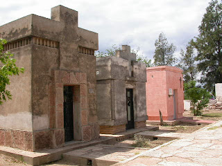
Anyway, a bit farther down the trail from the buggy hermitage I encountered a typical cemetery in SE La Rioja Province. These photos of a few of the mausoleums will show that once upon a time, these people had the money to be interred in style, but I think it is all old Argentine money, as the faces on the tombs all looked like their prime was in the early days of the 20th Century. The town this particular cemetery is located is known as Serrezuela, and is located just west of the Córdoba Provincial boundary. I thought it was also interesting to note that there were almost as many mausoleums in the cemetery as there were houses in the town...
 Farther south still, I reached the point where Ruta Nacional 38 connects with Ruta Provincial 15 (Córdoba Province), which is my road that will take me into Villa Dolores tomorrow. As I followed this route, I got another good blast of rain (see photo of the storm) which was enough to wash off all the dead bugs from my windshield. The river in the photo was also from the same spot as the cumulus cloud picture - just looking down off the bridge instead of up to the sky.
Anyway, like I said, I got farther today than I had expected, finally booking a room in a nice hotel in the somewhat tourist town of Mina Clavado. But now that it is March 1st, tourist season is past, so I think I can enjoy the somewhat mellow atmosphere, and will continue doing that for a time in the morning, since Villa Dolores is only 50 km away.
When I pull in there around noon tomorrow I will be meeting the father of my friend Matias Martino for the first time. I am planning to stay there through March 3rd, and then will start my way back to Chile on the 4th.
Stay tuned, there is still plenty of territory to cross on this one, which means numerous potential adventures.
Chao, for now, amigos.


1 comment:
Great trip...We have been keeping track of you on the National Geo. Atlas..Have given this blog to several other people and they are along for the ride, also...Excelent photos...Thanks for letting us "Ride" with you!...
Good Luck....Skip& Karin Schott..Snohomish, Washington..USA
Post a Comment